🇹🇭 Mae Hong Son, Thailand · Ban Huai Phueng Mai, Mae Tho subdistrict (community)
Doi Ko Mu Le (Kumole)
ดอยกอมูเล
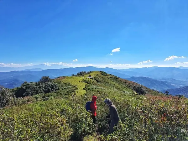
Photo: Khow Puttaraksa · All rights reserved. Do not use without permission.
Difficulty: Easy
About this place
A mountain in Mae La Noi on the Mae Hong Son–Chiang Mai border; according to reviews its original Hmong name means 'dragonfly'. The summit, about 1,754 m, is open grassland with 360-degree views, a sea of mist on clear mornings and bright stars at night. The trail follows an old road that the forest has reclaimed — vehicles can no longer get through, so it's on foot only.
Highlights
- Grassy summit with 360-degree views
- Sea of mist and stars from the top
- Can be linked on to Pha Loe Ke Kui and Doi Luang Khun Mae Nai, according to reviews
Day by day
- Day 1: 5.5 km · about 3 hrs on foot — Camp near the summit of Doi Ko Mu Le
- Day 2: 5.5 km — Up to the viewpoint, then back down the same way (or another night for the 3-day, 2-night trip)
5.5 km to the camp, about 3 hrs, from Readme.me. The 11 km return is worked out from the one-way distance and excludes the 2 km pickup ride.
Before you go
Park at Ban Huai Phueng Mai school, Mae Tho subdistrict, Mae La Noi district, then take a villager's pickup about 2 km to the trailhead (a Pantip review says the pickup ride from the Mae Tho turn-off into the village is almost 40 km, with potholes and standing water on the later stretch). It's about 5.5 km, roughly 3 hours, to the camp. You can do it as 2 days, 1 night or 3 days, 2 nights. The trail is open because it was once a road, but it's steep almost the whole way. Midway it splits in 2: the left branch skirts the hill and isn't steep; the right branch is steeper but has better views. Porters and guides are available in the village (reviews give no price). Total trip cost per a Pantip review was a little over a thousand THB per person (group of 6, year not given). The camp is windy all year and you can't hang a hammock — you have to go a little way downhill. There's a water source not far from the camp. Village shops may not sell bottled water, so bring your own. Leeches, especially in the rainy season — bring leech repellent. A 2016 review said the area wasn't yet officially open to tourism; a 2022 review said you can go but it still isn't official. Always check with the community leader or local authorities before you go. All information comes from user reviews, not from any official body.
Do you need a guide? Book a slot with the park and ask about guides and porters when you book
Sources
Nearby places
- Ang Ka Nature TrailChiang Mai, Thailand · 41 km away
- Kew Mae Pan Nature TrailChiang Mai, Thailand · 41 km away
- Pha Ngaem (Pha Song Rue Du / Two Seasons Cliff)Chiang Mai, Thailand · 41 km away
- Doi Pha Khao (Mae Chaem)Chiang Mai, Thailand · 43 km away