🇹🇭 Phitsanulok, Thailand · Thung Salaeng Luang National Park (Ban Mung)
Khao Long Ruea Ta Muen (Ban Mung), Phitsanulok
เขาล่องเรือตาหมื่น
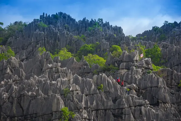
Photo: Ohmpassakorn · CC BY-SA 4.0
Difficulty: EasyDay trip
About this place
A jagged, spear-tipped limestone ridge rising from the Ban Mung plain, which locals call the jewel of Ban Mung. Fossils about 286–360 million years old have been found here. The name comes from a story that a military officer of 'Muen' rank came up to cut a takhian tree to build a boat. The climb is short but involves scrambling up sharp rock with ropes, then waiting for sunset and sunrise over the limestone hills.
Highlights
- Spear-like limestone summit
- Sunrise and sunset viewpoint
- Crawl through Tham Duean–Tham Dao caves in Ban Mung
About 1 km on the flat through plantations, then a climb up the limestone — some sections steep, some along boulders, with ropes for support. Ascent about 1 hr 30 min (TAT). No source gives a total distance.
Before you go
A spear-tipped limestone peak at Ban Mung Nuea, Ban Mung subdistrict, Noen Maprang district, managed by Thung Salaeng Luang National Park. You must request permission to enter Thung Salaeng Luang National Park at least 3 days in advance (TAT); no walk-ins. Contact the Facebook page of the community group that runs the Khao Long Ruea Ta Muen climb, or ask the park. A local guide is required (one review says 1 guide per hiker). Packages cost about 1,500–3,000 THB per person depending on a day trip or overnight, including park entry, guide, drinking water, dinner and breakfast, and safety gear (gloves, helmet). Prices may change, so ask before booking. The meeting point is Tham Duean–Tham Dao, where staff pick you up. You walk about 1 km on the flat through rubber and mango plantations, then start climbing; the ascent takes about 1 hr 30 min. You can stay overnight at the campsite halfway up (rent a tent or bring your own), then go up to the high point for sunrise. No showers on the mountain. It's about 350 km from Bangkok; a van or minibus from Mo Chit 2 to Noen Maprang takes about 5–6 hours. The summit is 176 m above sea level. Caution: although the HUPKAO team rates it easy, the limestone is razor-sharp all over the top, the ground is uneven and ankles twist easily, and there are rope climbs and steep ladders. Wear a helmet, gloves and breathable clothing that protects against cuts from the rock. It's hot and windless on top; warm up before you climb to avoid cramp, and bring enough water and electrolytes.
Do you need a guide? A local guide or porter is required
Contact the park
Thung Salaeng Luang National Park, Nakhon Thai district
Sources
Nearby places
- Thung Salaeng LuangPhetchabun, Phitsanulok, Thailand · 18 km away
- Man Daeng Waterfall (Phu Hin Rong Kla)Phitsanulok, Thailand · 56 km away
- Phu Hin Rong KlaPhitsanulok, Phetchabun, Thailand · 56 km away
- Sai Thong Siam Tulip Fields (Thung Bua Sawan)Chaiyaphum, Thailand · 111 km away