🇭🇰 Hong Kong
Tai Mo Shan, Hong Kong
ไทโหมวซาน (ไท่หมอซาน)
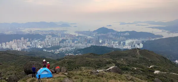
Photo: Nhk9 · CC BY-SA 4.0
Difficulty: ModerateDay trip
About this place
Hong Kong's highest peak at 957 m, in the middle of the New Territories; the name means big misty mountain. It is the coldest place in Hong Kong and some years sees frost. Walk up the road to the weather radar or from Ng Tung Chai Waterfall, with views of Tai Po and Shenzhen on clear days.
Highlights
- Hong Kong's highest point, 957 m
- Weather radar dome on the summit and the Tai Mo Shan viewpoint
- Ng Tung Chai Waterfall on the way (if you take that route)
Several routes; the figures depend on which one you choose.
Before you go
No permit and no entry fee. Tai Mo Shan's 957 m summit is the highest point in Hong Kong, inside Tai Mo Shan Country Park (1,440 hectares according to AFCD), but the very top has a Hong Kong Observatory weather radar station, so you can't actually reach it. The route described by HikeHK climbs to about 920 m. The route recommended by AFCD/Hiking.gov.hk is to take public transport to the Tai Mo Shan Country Park stop (KMB bus 51), then walk up Tai Mo Shan Road, about 10 km and about 3.5 hrs. Another route starts at Ng Tung Chai Waterfall and passes the waterfalls on stone steps that are steep in places. There are several ways up, so the figures vary: Hiking.gov.hk 10 km, 3.5 hrs; HikeHK 9.7 km, 4 hrs (MacLehose Trail section 8); Journeyera 10.37 km, 2 hrs 40 min moving time (895 m total ascent). Getting back: HikeHK suggests bus 15 to Tsuen Wan, while Journeyera suggests bus 51M from the Tai Mo Shan Country Park visitor centre to Tsuen Wan MTR station (infrequent). No readable fare figures were found; the 5–10 dollar budget is only an estimate based on typical Hong Kong bus and MTR fares, not from a direct source. The summit is often covered in cloud and mist (the name means big misty mountain). Check the weather and avoid going after heavy rain because of flash-flood risk along the waterfall route. Bring a warm layer.
Sources
- Hiking.gov.hk (Enjoy Hiking, AFCD): Tai Mo Shan
- afcd.gov.hk
- HikeHK: Tai Mo Shan hike
- Journeyera: Tai Mo Shan hike
- Wikipedia: Visa policy of Hong Kong
- openstreetmap.org
Nearby places
- Lantau Peak (Fung Wong Shan), Hong KongHong Kong · 28 km away
- Longji Rice Terraces: Ping'an to DazhaiChina · 551 km away
- Wugong MountainChina · 562 km away
- Alishan Forest Recreation AreaTaiwan · 694 km away