🇩🇪 Germany
Heilbronner Weg (Allgäu Alps, Oberstdorf)
เส้นทางสันเขาไฮล์บรอนเนอร์ (Heilbronner Weg)
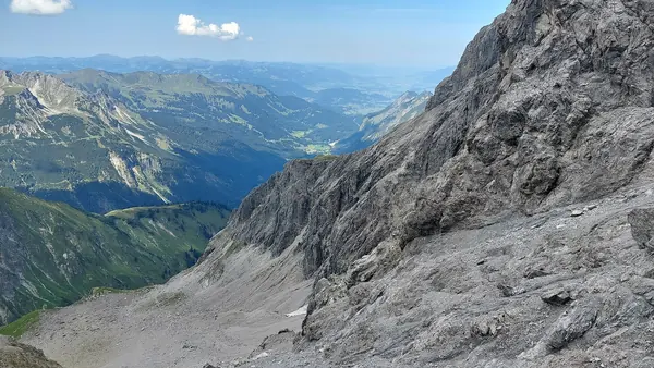
Photo: Harald Hetzner · CC0
Difficulty: Hard
About this place
A high route along the main ridge of the Allgäu Alps near Oberstdorf in southern Germany, open since 1899. It squeezes through a narrow rock gap, climbs an iron ladder and follows a ridge above 2,400 m the whole way, with views over hundreds of Alpine peaks. One or two nights in mountain huts.
Highlights
- The Heilbronner Törle rock gap, plus the ladder and bridge on the Steinschartenkopf
- The Rappensee lake by the Rappenseehütte, the largest hut of the German Alpine Club
- Add the Hohes Licht (2,651 m) before the ridge
Day by day
- Day 1: 12 km · about 4–5 hrs on foot — Rappenseehütte
- Day 2: 18 km · about 7–8 hrs on foot — Kemptner Hütte, then down to Spielmannsau
Distances from the Bergeaktiv blog: day 1 from Alpe Eschbach to the Rappenseehütte (including the Rappenseekopf) about 12 km, 4.5 hrs, about 1,500 m up. Day 2 from the hut up the Hohes Licht, along the ridge, past the Schwarzmilzsee lake and the Kemptner Hütte down to Spielmannsau, about 18 km, 8 hrs, about 800 m up and 1,800 m down. The blog rates the ridge T4; Tourismus Oberstdorf suggests spreading the tour over 2–3 days. Side peaks: Hohes Licht (2,651 m), about 1.5 hrs up and down; Mädelegabel (2,645 m), easy scrambling, about 1 hr up and down.
Before you go
No permit needed, but Tourismus Oberstdorf calls it the most demanding high route in the Allgäu Alps. The ridge section stays above 2,400 m the whole way, is steep and exposed, and has steel cables, an iron ladder and an aluminium bridge, much like an easy via ferrata — but the cables do not cover every difficult stretch. You need to be sure-footed, completely free of vertigo, fit, and experienced in the mountains, especially at reading the weather and crossing old snowfields. A helmet is recommended. Beginners should not go alone, and it is not suitable for children under 12; if unsure, go with a mountain guide. The usual 2-day route: on day 1, take bus 7 from Oberstdorf to Alpe Eschbach and walk up to the Rappenseehütte (2,091 m) — the hut gives about 3–3.5 hrs from the Fellhornbahn car park (private cars cannot drive further up the valley). On day 2, start early and follow the ridge from the Heilbronner Törle over the Steinschartenkopf and Bockkarkopf to the Bockkarscharte, then on to the Kemptner Hütte (1,844 m) — the huts give about 5–6 hrs from hut to hut — and descend through the Sperrbachtobel gorge to Spielmannsau for bus 8 back to Oberstdorf. You can also spend a second night at the Kemptner Hütte (2–3 days in all). In rain or thunderstorms there is an emergency descent via the Socktalscharte to the Waltenberger Haus, a little past halfway along the ridge. Walk in this direction so the hard section falls in the morning, before the afternoon storms. Book beds at both huts through hut-reservation.org; contact the Rappenseehütte by email only. Weekends in the school holidays get crowded, so the tourism office suggests a weekday. Dogs cannot stay at the Rappenseehütte. No official 2027 hut prices found yet — check the booking system. Check the latest trail conditions in Oberstdorf's Bergsportbericht before you go. Emergency number in Germany: 112.
Sources
Nearby places
- Seebensee & Drachensee from Ehrwald (Zugspitze, Tyrol)Austria · 50 km away
- Alta Via 1, DolomitesItaly · 152 km away
- Oeschinensee Panorama Hike, KanderstegSwitzerland · 213 km away
- Tour du Mont BlancFrance, Italy, Switzerland · 307 km away