🇨🇭 Switzerland
Oeschinensee Panorama Hike, Kandersteg
ทะเลสาบโอชิเนน (Oeschinensee)
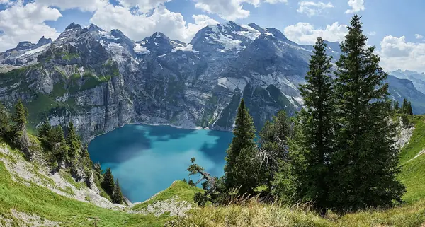
Photo: Günter Seggebäing, Coesfeld · CC BY-SA 3.0
Difficulty: ModerateDay trip
About this place
A turquoise lake beneath the giant rock walls of the Blüemlisalp and Doldenhorn, inside the Swiss Alps Jungfrau-Aletsch World Heritage Site. Ride the cable car up from Kandersteg village, then walk the panorama loop climbing high above the lake, through alpine meadows and past the Bärgli waterfall, before heading down to relax by the water.
Highlights
- Heuberg viewpoint looking down on the lake
- Alpine meadows and the Bärgli waterfall, with a chance of ibex
- Swimming and lakeside restaurants
The panorama loop starts and ends at the top cable car station: cable car station – Lägern – Heuberg – Oberbärgli – Unterbärgli – lake – cable car station. About 453 m up and down, high point about 1,987 m. If you walk up from Kandersteg instead of taking the cable car, add about 90 minutes for the ascent. The Photo Hikes blog walked a long loop from Kandersteg: 17.3 km in total, 870 m of ascent, 7–7.5 hrs.
Before you go
No permit and no entry fee. There are 2 ways up: (1) take the cable car from Kandersteg to the top station and walk from there. In summer, until 8 Nov 2026, you must also book an uphill time slot in advance in addition to your ticket. A return adult ticket is 36 CHF (9 May – 14 Jun and 22 Sep – 9 Nov 2026) and 40 CHF (15 Jun – 21 Sep 2026); Swiss Travel Pass or Half-Fare holders get 50% off. The cable car runs 08:30–18:00 (until 17:00 late in the season). (2) Walk up from the Kandersteg valley, about 90 minutes and about 450 m of climbing; hiking boots recommended. The most popular route is the panorama loop via the Heuberg and Oberbärgli viewpoints. It's a mountain path that crosses steep slopes above deep drops, so you need to be sure-footed and wear hiking boots. In May there may still be avalanche snow on the ridges. For an easy walk, there's a wide path from the cable car station to the lake, about 25 minutes, suitable for pushchairs. Caution: the blue-and-white (T6) route on the other side of the lake is exposed and steep with rockfall, and not suitable for most people. Some routes close temporarily, e.g. route B (Hubel) is closed for construction work; check route status on the operator's website before you go. There are restaurants around the lake and you can swim. The budget on the site is based on the cable car fare, converted roughly to USD.
Sources
- oeschinensee.ch
- oeschinensee.ch
- adelboden-lenk-kandersteg.ch
- alltrails.com
- thephotohikes.com
- openstreetmap.org
Nearby places
- Tour du Mont BlancFrance, Italy, Switzerland · 99 km away
- Heilbronner Weg (Allgäu Alps, Oberstdorf)Germany · 213 km away
- Seebensee & Drachensee from Ehrwald (Zugspitze, Tyrol)Austria · 262 km away
- Alta Via 1, DolomitesItaly · 334 km away